Accuracy of seismic events location
Here we will consider regional seismic events (distances from an event to seismic stations less than 3000 km) and location using first arrivals of seismic waves. As usual we use first arrivals of P and S waves.
There are several factors which influence on accuracy of seismic events location and their depths determination.
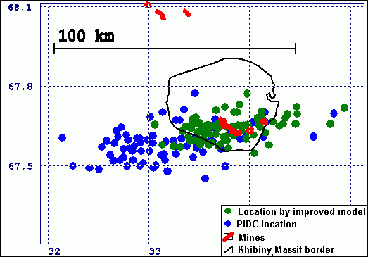
Location of mining explosions in Khibiny Massif by PIDC system
The picture shows results of location of mining explosions in Khibiny massif by international monitoring system PIDC (Prototype of International Data Centre) in 1995-1997. Blue markers are locations made in PIDS using 1D travel-time model IASPEI91.
It is easy to see that the coordinates have systematic error of about 50 km (mines are marked by red in the picture).
Green signs mark locations of the same explosions by the same data but made using travel-time model which we had developed using reference ground truth events for our region. Systematic errors disappeared!
Thus, errors in travel-time model can lead to significant (dozens of kilometers) location errors.
We made a study to find out what could be location accuracy in our region, and especially accuracy of depths determination if we suppose that we use ideally accurate travel-time model.
The question become of interest for us when we analyzed recordings of several seismic events near Spitsbergen.

Recordings of North-East Land event (the part of Spitsbergen Archipelago). Low frequencies are filtered till 2 Hz.
The recording has the following features:
- multiple P-wave onsets;
- multiple S-wave onsets are not visible, probably they are masked by P-wave coda;
- weak P onsets are visible only after signal filtration;
Note that if the event was weaker of if it was registered by analog seismic station it would be impossible to notice first P arrivals. In this case error of P time estimation could be up to dozens seconds!
The figure below shows attempts to locate the event (lines P-P, P-S are shown as well as backuzimuth line from Spitsbergen seismic array (SPI)). Two variants of location are shown. The first one using weak P onsets, the second one by strong onsets of P and S.

a) By first onsets

b) by strong onsets;
Two variants of location of earthquake in North-East Land.
It is easy to see that in first case the lines diverge significantly i.e. measured P and S onsets are different phases of the waves arrival. In the 2nd case the lines are in much better agreement. This confirms our supposition that those S onset which is visible on the recording is not the 1st S onset whereas the 1st one is masked by P coda.
Thus location of this event is not reliable. Errors of onsets measurements can reach dozens of seconds and errors of coordinates can be up to hundreds of kilometers. This can be stated for many seismic events near Spitsbergen.
Spitsbergen Archipelago is extreme case of very complicated medium. But similar problems often appear during location of events occurred in different areas. A good example is seismic event 23.02.2002, Novaya Zemlya, coast of Kara Sea. The event was well-recorded by regional seismic stations (see picture).

Recordings of 23.02.2002 event near Novaya Zemlya by regional seismic stations. Filtered in a band 4-8 Hz.
P and S arrivals are shown in figure below. The arrivals are aligned i.e. reduced to some conventional time.

a) P-wave onsets;

a) S-wave onsets; Aligned P and S onsets for 23.02.2002 event
The onsets are indistinct, the uncertainty of time can reach seconds for P and dozens seconds for S waves.
We tried to estimate how location and depth determination depend on such uncertainties in P and S onsets measurements. We use the following approach:
- For each station pick several possible variants of arrival times for P and S: Tpij and Tsij, where i - station, j - variant;
- For each combination of the onsets variants Tpi*, Tsi* make location and depth estimation (Minimization of standard deviation of origin time). Thus we obtain a set of locations, depths and estimations of self-consistency: (jk, lk, Hk, st0k), k-index of variant;
- Plot distribution of locations and depths for most self-consistent variants: (st0k < st0 average/2)
We made this study for a set of well-known events in our region (Novaya Zemlya, Kara Sea, Northern Norway, Kola Peninsula) including the event 23/02/2002 mentioned above. (See fig. below)
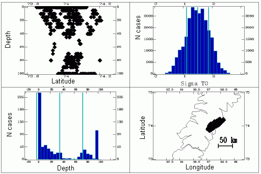
Variants of location of event 23/02/2002.
The figure contains the following parts: left top: depth section of location results, left bottom: distribution of depths; right bottom: map of points which are variants of locations. Such cloud of points could be an alternative for so-called 'error ellipse'.
It is easy to see that error of coordinates determination could be about 50 km. In accordance with the depth distribution plot the most probable depth is 0, although there are several variants (of P and S measurements) where the depth can reach 80-100 km. Since all the variants have the same probability it is clear that we can use the term 'depth' only in statistical meaning as 'more probable depth'.
The same analysis made for other events led us to some simple conclusions:
- for rare seismic networks there are principle irreducible limitations of location by first onsets. The limitations are connected with accuracy of coordinates and especially depths determination;
- scattering in depths estimations caution against using of depth as events discrimination parameter;
- to improve location in many cases it is necessary to understand better waves propagation in complicated media. This probably require 3D modelling of waves propagation;
- the method for computing 3D area of locations errors was developed which is alternative to 'error ellipse'.
There are only few local seismic events for which we can definitely state that they had occurred at significant depths. It can be done by apparent velocities of P-waves for seismic arrays.
Apparent velocities are computed during backuzimuth estimations bu seismic arrays:
Vapparent = Vtop layer / cos a,
where a is angle between wave arrivals direction and day surface.
The parameter Vapparent is rather unstable. Thus, for Apatity array and explosions at distances till 150 km it is about 5.5-7 km/sec. For explosions at larger distances it appeared to be in a range 7-10 km/sec.
Nevertheless, there are some events for which Vapparent is several times greater than the same for explosions at the same distances. Thus for instance for event 26.06.1996 in Imandra Lake area Vapparent for P-wave appeared about 50 km/sec, for S-wave it was about 30 km/sec. The same results were obtained for several weak seismic events in Khibiny Massif. Such events were certainly identified as earthquakes.